Magnetic surveys play a crucial role in the field of geophysics, providing valuable insights into the subsurface characteristics of the Earth.
The technique measures variations in the Earth's magnetic field, these surveys help neuroscientists identify underground structures, mineral deposits, archaeological sites, and more. A professional Geophysicist is best to manage and interpret the surveys because of their training about the principles, applications, and limitations of magnetic surveys.
Its another way we "see" underground without x-ray glasses. These surveys involve measuring the natural magnetic properties of rocks and minerals to create underground maps.
magnetic surveying has been around long before bullwhips and fedoras.. so Forget Indiana Jones. Magnetic surveying was initially used by geophysicists to study the Earth's magnetic field since the 1800's and later and its evolved into a crucial tool for various fields like geology and archaeology.
Imagine having a compass that points not just north but also towards hidden treasures underground. That's the magic of magnetic fields. Rocks contain tiny magnetic minerals that align with the Earth's magnetic field, helping us map what lies beneath the surface.
Not all rocks march to the same magnetic beat. Magnetic anomalies occur when there are variations in the magnetic properties of rocks underground. These anomalies can signal changes in rock types or even hidden ore bodies waiting to be discovered.
Scientists use magnetometers to measure the strength and direction of magnetic fields. By collecting data across a survey area, they can create detailed magnetic maps for analysis.
Magnetometers are the workhorse of magnetic surveys, measuring the strength and direction of magnetic fields in the Earth's subsurface. They come in various types, from the traditional hand-held models to more advanced drones and towed arrays.
Data acquisition systems are used to collect, store, and process the raw data obtained from magnetometers. These systems can range from simple field computers to sophisticated software that allows real-time monitoring and adjustment of survey parameters.
Survey planning tools help geophysicists design effective magnetic surveys by determining optimal survey parameters such as line spacing, sensor height, and sampling intervals. These tools use mathematical models to simulate the expected response of subsurface magnetic structures. :Lines are planned and set before and all data is matched to accurate coordinates using onboard GPS
Modern prospectors locate mineral deposits like gold, iron, and copper hidden beneath the Earth's surface. Who needs a treasure map when you have a magnetometer?
Uncover the secrets of the past without disturbing ancient ruins. Archaeologists use magnetic surveys to identify buried structures, artifacts, and even lost cities without picking up a shovel (although digging is still half the fun).
You don't want to stumble upon buried explosives like it's a twisted game of Minesweeper. Magnetic surveys are crucial for detecting unexploded ordnance in war-torn areas, helping to safely dispose of these hazardous relics and ensure peace.
Magnetic surveys are valuable tools in resource exploration, particularly for identifying mineral deposits, mapping geological structures, and delineating hydrocarbon reservoirs. They are cost-effective, non-invasive, and can cover large areas quickly.
Magnetic surveys have limitations in complex geological settings where multiple magnetic sources overlap or when subsurface conditions are highly variable. Interpreting magnetic data in these settings can be challenging and may require additional geophysical methods for accurate characterization. Industry professionals can uncover hidden insights beneath the Earth's surface.
It uses a magnetic sensor to passive;y ,measure the earths magnetic field, it can be collected on ground or in the air at a fast rate.
Proper survey set up and supervision by a geophysicist
Aware that magnetic features like cars, steel and other metal objects ear the line can affect the data
Removal of drift from data
operators kept clean of magnetic objects
Proper reduction and professional processing
Integrating Reduced to Pole magnetic maps into exploration strategies offers a powerful tool for enhancing subsurface imaging and identifying geological structures. This article explores the fundamentals of Reduced to Pole magnetic mapping and its importance in modern exploration practices. By delving into the benefits, interpretation techniques, case studies, and best practices associated with this innovative approach, readers will gain a comprehensive understanding of how to effectively incorporate Reduced to Pole magnetics data into their exploration strategies.
# 1. Introduction to Reduced to Pole Magnetic Mapping
## 1.1 What is Reduced to Pole Magnetics Mapping?
Reduced to Pole magnetic mapping is like giving your magnetic data a makeover - transforming it into a more readable and simplified form. It's the equivalent of magnetic contouring's glow-up.
## 1.2 Importance of Reduced to Pole Transformation
Reduced to Pole transformation is not just a fancy trick. It's a game-changer in exploration as it helps to strip away complexities and reveal the true magnetic story beneath the surface. Think of it as the X-ray vision goggles of geophysics.
# 3. Interpretation Techniques for Reduced to Pole Magnetics Data
## 3.1 Magnetic Anomaly Analysis
The Reduced to Pole magnetics data isn't just for show. Through magnetic anomaly analysis, geoscientists can decipher the mysteries hidden in the magnetic signatures, like cracking a code to unveil the geological secrets beneath.
## 3.2 Depth Estimation Methods
With the help of Reduced to Pole magnetics data, depth estimation becomes a more precise science. It's like using a measuring tape instead of just guessing the depth of a swimming pool. It brings accuracy and confidence to exploration strategies.
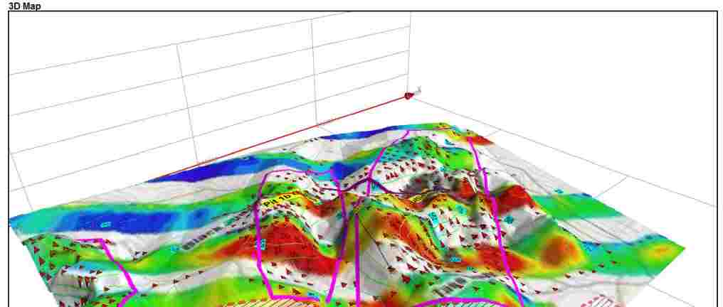
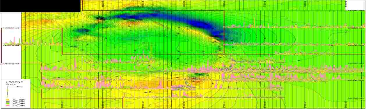
# 4. Case Studies Demonstrating Successful Integration
## 4.1 Application in Mineral Exploration
Reduced to Pole magnetics maps have proven their worth in mineral exploration by guiding geologists to mineral-rich targets with greater accuracy. It's like having a treasure map that actually leads to the gold mine.
## 4.2 Utilization in Oil and Gas Exploration
In the realm of oil and gas exploration, integrating Reduced to Pole magnetic data has helped in identifying potential reservoir structures and optimizing drilling locations. It's like finding the sweet spot on a dartboard every time - hitting the bullseye with precision.
Reduced to Pole magnetics can be a powerful tool in exploration strategies, providing valuable insights into the subsurface geology. To make the most out of this data, certain best practices must be followed to ensure accurate interpretations and robust exploration outcomes.
When acquiring Reduced to Pole magnetics data, it is crucial to pay attention to deta
The Geophysical Supervisor can prioritize key issues such as sensor orientation, flight line spacing, and noise reduction methods. To ensure accurate and reliable final results, it is crucial to use proper data processing techniques. This includes making corrections for diurnal variations and drift. Furthermore, quality control measures should be implemented throughout the data acquisition and processing stages to identify and address any potential errors.
(Combining different things together so they work as one unit) Reduced to Pole magnetic with other geophysical methods, including gravity surveys, earthquake-related data, or (related to electricity producing magnetic fields) ways of doing things, can provide a more complete and thorough understanding of the subsurface features. Reduced to Pole magnetics maps represents a valuable thing in the exploring things toolkit, providing (understandings of deep things) that can lead to significant discoveries in different businesses. By taking advantage of the benefits, (understanding/ explanation) ways of doing things, and best practices, exploring things professionals can improve (as much as possible) their (success plans/ways of reaching goals) and unlock the full (possible power or ability within/possibility of) their land and rock-based surveys.
A magnetic feature is located directly beneath the magnetic target, simplifying the exploration process.
Consistent presentation
Reduced pole magnetic data can greatly influence exploration results. Geoscientists can develop a better understanding of mineral structures and identify potential mineral deposits more effectively. This improved exploration can lead to more precise targeting of exploration activities, ultimately increasing the likelihood of successful mineral discoveries.
For info contact Grant Roberts:
Phone:
+855 10 863111