MASW Seismic to mp rock depth along a pipe jacking line
MASW survey Singapore
A MASW Seismic survey was conducted along the pipeline jacking route of Bukit Batok East Ave 2, Bukit Batok (MH1 to 2a),
The goal was to accurately map rock depth and update the geological record so the data from shafts better matched the known geology. The MASW data did show the same features as shafts driven to 30m +
Singapore Pipe line route
A map of actual Line
The survey sought to explore the depths of rock and potential problems along the pipe jack line using MASW seismic.
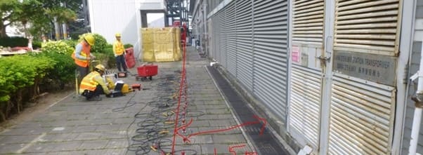
Seismic line 1
Field equipment
The survey relied heavily on the Geometrics Geode system, a high quality collection system
The seismic system and computer were set up on the ground Later, ground marks were picked up and related to the field data.
This give files that are converted to shear wave velocity plot that can then be related to rock depth from dug shafts and comared to rock depth from client supplied bores
Seismic data Collection - Pipe Thrust Line
Inverted section step 1.. Dispersion image
Review the MASW sections - the one on the left represents the basic frequency and the bent part reveals the shift from shear wave velocity 200m/sec in weathered rocks to 800m/sec in unaffected stones, approximately 50 m from the MH1 bus shelter along Line 2a.
MASW Section
Inverted section step 2 - Velocity versus depth
Observe the increase in shear wave velocity at 14m, pointing to the presence of granite Grade G3 (as interpreted), and the further surge in shear wave velocity at 19m that changes to granite Grade G2 (as interpreted). Here is an example of the velocity model for the beginning of Line 1 (Line 1, 0m distance from MH2a).
Velocity versus depth
Processsed Cross section
Analysis of our MASW data shows that the shift from G5 to G4 follows an up-and-down trend from depths to higher shear wave velocity from 12 to 20 metres. Additionally, the transition from G4 to G2/3 exhibits a fluctuating pattern, ranging from shallow near MH2a (12 metres) to as deep as 22-25 metres at a distance of 100-150 metres, before levelling off to depths of 12-15 metres close to MH1. The shaft depth and the rock on the left-hand side is rthge same. This independently confirm the validity of the MASW.