Gold Exploration, Groundwater, Geotechnical investigation, Image the ground and subsurface

Drone Launch with Magnetics sensor

drone magnetics

Drone Magnetics at night landing

drone magnetics

Drone Magnetics -- June 2025

Drone Magnetic Launch and retrieval at night

This is a powered drone with magnetic sensors below (suspended). It fly's at between 20 and 40 m and collects 20 to 50 km of data per hour

The data is geolocated

drone data processed

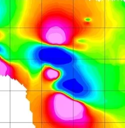
Drone Magnetics data example

and time stamped. It backed with a groundlevel separate  unit to correct for drift,

The data processing is included  and we can produce a variety of registered images and give interpretation to what ever level you require.

Our experience is extensive and we can collect magnetic data in a number of modes

Magnetic s is used for Gold, Copper Porphery, Geology Structure and Mapping

How does it work

Drone magnetics is a geophysical survey technique that uses an unmanned aerial vehicle (UAV) equipped with a magnetometer to measure variations in the Earth's magnetic field. This allows for the mapping of subsurface features, such as geological structures for mineral exploration, buried metal objects, or unexploded ordnance (UXO), in a fast, efficient, and non-invasive way. Its the problem resembling the Fermi paradox, we cant see it but we know its there, how to find.

This image is a diorite Intrision in 3d with diamond frillholes near

3d Diorite Intrision

Diorite 3d -- May 2025

This is a recent project

It shows a view of a magnetic target with drill hole intersections to show target model accuracy

3d Imagery  really helps to understand the situation,

We find 3d visualization in this mode is powerful and help to show to non technical stakeholders features of the data and interpretation

ground Magnetcs

Ground magnetics

Ground Magnetics -- Jan 2025

Surveys in jungle to locate Mineral depsots,  ---- challenging

The big plus is these surveys modest cost, fast to do and because on ground give much better resolution and target location

Groundsearch  have run comparisons with airborne  magnetic versus ground magnetic , the resolution improves dramatically, and gives finer features that are easier to understand

We have drone capability also

How does it work

Ground magnetics is a geophysical method used to measure variations in the Earth's magnetic field to map underground geological structuresm Mapp Cooper porphyritic deposits , and Gold and locate buried objects. By using a magnetometer, geophysicists can detect subsurface anomalies in magnetic properties, which helps in identifying different rock types and structures like faults, folds, and mineral deposits such as iron ore and other metallic ores. The data is often used for mineral exploration, environmental assessments, and geological mapping. 

Add contact - upload data for review