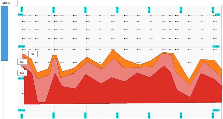
Gold Exploration, Groundwater, Geotechnical investigation, Image the ground and subsurface

locate site with eri
SEismic - MASW data

Technology & Innovation  ·  June 2025

Smarter Ground, Sharper Results

How AI is transforming our geophysics data processing for IP, resistivity and seismic surveys

Geophysics has always been a data-intensive discipline. A single induced polarisation (IP) or resistivity survey across a mineral exploration licence can generate hundreds of thousands of electrode readings. A multi-channel seismic line produces equally dense waveform datasets. Turning those raw numbers into a reliable subsurface picture has traditionally relied on skilled interpreters and weeks of iterative processing.

At Groundsearch, we have spent more than three decades developing that expertise across Southeast Asia, the Pacific, and beyond. Now we are integrating artificial intelligence and machine learning directly into our processing workflows — not to replace the geophysicist, but to make their judgement faster, sharper, and better-informed.

“The goal is not automation for its own sake. It is getting a higher-quality answer into the client’s hands in less time, with greater confidence.”

— Groundsearch Technical Team

Where AI Is Making the Biggest Difference

IP & Resistivity Inversion

Neural network models suggest optimal starting models and regularisation weights, reducing inversion artefacts and cutting iteration cycles by ~40%.

📡

Seismic First-Break Picking

A supervised model picks first arrivals across MASW and refraction lines up to 3× faster than manual workflows, with consistent accuracy.

🔍

Noise Detection & Removal

Anomaly detection distinguishes genuine subsurface signals from cultural noise, electrode contact issues, and EM coupling automatically.

📊

Interpretation Support

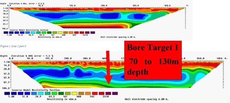
Clustering tools rapidly identify lithological boundaries, alteration zones, and groundwater targets from resistivity cross-sections.

Results That Speak for Themselves

~40%

reduction in IP & resistivity inversion time

faster seismic first-break picking

30+

years of regional field data training our models

IP and Resistivity: A Closer Look

Induced polarisation surveys are among our most powerful tools for mineral exploration and groundwater investigations. The technique measures both the resistivity of the ground and its chargeability — the tendency of earth materials to store electrical charge. Sulphide mineralisation, graphite, and clay-rich aquifer zones all produce distinctive chargeability signatures that resistivity alone cannot resolve.

We are now using a convolutional neural network, trained on a library of forward-modelled IP responses, to generate starting model candidates ranked by their likelihood of producing a stable inversion. This reduces the number of iterations required and produces final models that our senior geophysicists validate in less review time.

Seismic Surveys: Velocity Models You Can Trust

Our seismic work spans MASW for geotechnical site investigations and refraction seismic for depth-to-bedrock mapping. We have integrated a supervised learning picker trained on field records from Cambodia, Laos, and New Zealand — handling the full spectrum of surface conditions we encounter across the region, from soft alluvial plains to residual tropical soils to hard rock outcrop.

“Southeast Asia’s varied geology is precisely why our AI tools need to be trained on regional data. A model calibrated on temperate-zone datasets will underperform on the deeply weathered profiles we encounter in Cambodia and Laos.”

— Groundsearch Technical Team

The Geophysicist Remains Essential

AI does not replace geological reasoning, field experience, or the professional responsibility of a qualified geophysicist. What it does is handle the repetitive, parameter-sensitive, high-volume aspects of data processing — so our team spends more time on expert judgement: designing survey geometry, assessing geological plausibility of inverted models, and integrating results with borehole and mapping data.

Whether you are exploring for gold or base metals in Southeast Asia, investigating a groundwater source in Cambodia, or commissioning a geotechnical site investigation — improved data processing means a clearer picture of what lies beneath your site, and a faster answer.

Ready to Get Sharper Results?

Talk to our team about your next IP, resistivity, or seismic survey in Southeast Asia or the Pacific.

📧 grant@groundsearch.biz 🌐 groundsearch.biz

Cambodia: +855 (0)10 863 111  ·  New Zealand: +64 21 191 6000  ·  Singapore: +65 9487 8061